Greenlandic Landscapes
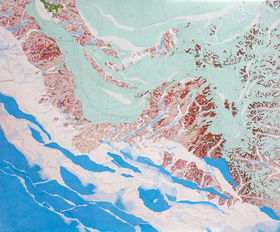
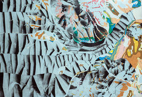
This project is about story-telling. The pieces tell stories of places around Greenland and their topographical features. The bedrock of each piece is a printed geological map donated by the Geological Survey of Denmark and Greenland (GEUS). These maps colourfully portray the geological diversity of Greenland’s ancient landscapes. While the maps define the geology and boundaries of these regions, the collage emphasises their modern stories. What dynamism is evident in the landscape? What is the ice doing to the terrain? How, and why? Here, the human component experiences the pushback of nature. The speed of ice-flow, the rapidity of the changing landscape, is clearly influenced by anthropogenic climate change.
GREENLAND´S ICE SHEET
Greenland is 80% shrouded by ice – a massive, frozen reservoir of fresh water that has existed for approximately 2.6 million years. The ice is replenished by snowfall, which has gradually compressed into what is now a 3000 meter-thick ice sheet. However, the ice is not a static, inanimate object. It is a dynamic, almost breathing entity, in constant flux and reaction to its surroundings, flowing from the interior to its edges, down the valleys like icy conveyor belts, pouring into fjords where it melts or breaks off as icebergs. The quantity of ice is so large that it is equivalent to 7.4 meters in depth, distributed over an area the size of the world’s oceans. When the ice sheet was in balance, the amount of snow accumulating on the surface was equal to the ice lost at the edges and sub-surface melt. However, since the 1990’s, as the Earth’s atmosphere and oceans have warmed due to rapidly increasing greenhouse gas emissions, Greenland’s ice sheet has lost its equilibrium. Ice losses due to enhanced melt, rain, ice flow and calving now far exceed the net gain from snow accumulation. The “Greenland’s Ice Sheet” Collection focuses on ocean-terminating glaciers, their history, patterns of movement and structure, and explores their fate under the influence of a warming climate. The Collection also addresses sea level rise as a consequence of the significant acceleration, retreat, and mass loss of these ocean-terminating glaciers. Greenland’s ice loss has so far contributed approximately 1 mm per year to global sea level rise over the past decade. Even if all the greenhouse gas emissions driving global warming ceased today, ice-loss in Greenland under current temperatures will still raise global sea level by at least 27.4 centimeters. Sea level rise poses a serious threat to coastal life around the world. Consequences include erosion of beaches, inundation of deltas as well as flooding and loss of marshes and wetlands, increased intensity of storm surges, flooding, and damage to coastal aquifers as a result of saltwater intrusion. In many cases, in addition to fragile wildlife habitats, these coastal areas are where we live, in large numbers. What happens in Greenland affects us globally.
DISKO ISLAND´S MUD VOLCANOES
Mud volcanoes, found in the West Greenland basin, for example in valley floors in Nunavik, Nuussuaq and Disko, differ from traditional volcanoes. They don't result from molten rock in the Earth's mantle but rather from pressurized subsurface fluids within sedimentary rock reservoirs. Factors like overlying sediment weight, tectonic forces, or gas accumulation trigger this pressure increase in the deep sedimentary layers, which is crucial for mud volcano formation. On Disko Island, these terrestrial mud volcanoes sit in areas where sedimentary rocks, such as sandstone and shale act as a seal and cover basaltic lavas. Faults or fractures breach the sedimentary seal, releasing trapped fluids and gases to the surface, forming mounds or cones of mud, as in northern Disko's Kuganguaq Valley, where several mud volcanoes align with such features. Disko Island´s mud volcanoes, ranging from a few to tens of meters in size, display various shapes like cones, domes, or craters. Some actively emit gas bubbles or mud streams while others lie dormant. Geologically linked to deep petroleum and natural gas reservoirs, they release mainly methane, a potent greenhouse gas that has 28 times greater global warming potential than CO2. These volcanoes are often surrounded by pools or mud lakes with diverse colors due to mineral or organic matter presence. These areas host unique micro and macro fauna adapted to extreme conditions. On the maps, mud volcanoes are marked with red star symbols that appear along the river valleys.

THE BURNING MOUNTAINS ON DISKO ISLAND
In 2010, smoke on the mountain on Disko Island in West Greenland was reported by the local authorities in Qeqertarsuaq. Researchers from GEUS and the University of Copenhagen discovered that it was not the volcanic activity, which some locals feared, but so-called 'burning schists' - a phenomenon that is not uncommon through the Disko area. The phenomenon is caused by the collapse of mountain slopes where coal-bearing shale is present in the rock. Reactive minerals such as sulphur in the coal that come into contact with oxygen, as well as the heat generated by the friction of sliding downhill, can trigger self-combustion. Not immediately, because the temperatures are low. Only slowly does the heat, generated by the oxidation reactions in the coal seam, rise until it sustains itself and causes the coal to ignite, which in some cases burns for hundreds of years. The "burning mountains" are mentioned in old Greenlandic legends of the Norsemen as early as 1300 AD. The phenomenon has also been documented repeatedly in more recent history, most spectacularly in 1933 and 1958 in Pujoortoq on the north side of the Nuussuaq Peninsula, where the brick-red color of the burnt shales can be seen from afar. Burning coal not only releases a significant amount of carbon dioxide, a powerful greenhouse gas, into the atmosphere, but also air pollutants such as sulphur dioxide, nitrogen oxides, particulate matter and volatile organic compounds. These pollutants have immediate and long-term negative effects on human health and the environment. They contribute to smog, acid rain, and respiratory problems.
DOLERITIC DYKES
When North America and Greeland rifted apart forming the Davis Strait, the Earth's crust was stretched and weak points in the rock were created, allowing magma that makes up the Earth's mantle to rise to the Earth's surface. The magma plumbing system consists of individual strands, like a tree with its branches, there is a main strand - the “dyke”, and numerous side strands - the “sills”. The particular composition of his system is referred to as “dolerite”. Occasionally, this plumbing system that fed these surface flows several tens of million years ago can be exposed by weathering, and this has happened frequently in Disko Bay. Dykes appear as long strips and, due to their greenish colour, stand in stark contrast to the light-coloured sedimentary rocks which they often intrude into. On the maps, the doleritic dykes are marked as long black lines on a light-coloured background, which run almost through the entire area of Disko Bay.

NORTHERN GREENLAND
The prominent mudstone inlier named ‘Monument’ sits at the centre of Hall Land, but the whole of Hall Land is a monument to the past. A monument to the peninsula’s namesake, the explorer Charles Francis Hall, who lies here in his lonely grave – a monument to the vast reefs of ancient sea creatures and their oily hydrocarbon offspring which dominate the landscapes of the south – a monument to the edge of Greenland’s Inland Ice, now retreated into itself – a monument to an ancient glacial sea which left its heart-beats in tide lines across the landscape.

SOUTHERN GREENLAND
South Greenland is a border between the wild Atlantic Ocean and the ancient, icy Greenland. It is a border in climate– home to the Vikings and an Arctic oasis bordering the icy walls to the north. Geologically, it is a border – the ancient mountains of the Ketilidians, which rose and fell again bordering the south extent of the great Archean North Atlantic Craton. Over millennia, the Earth's great continental plates slowly collided with Greenland’s stoic core, folding, fracturing, concertinaing, and eventually calming into the exotic, multi-coloured tapestry of rocks that is South Greenland.

ISUA SUPRACRUSTAL BELT
Partly concealed by the Inland Ice, the rocks of the Isua Supracrustal Belt near Greenland’s capital, Nuuk, are a mirror reflecting some of the most ancient stories of our Earth. Preserved in this 3.8 billion year old rock formation are stunning, multi-coloured rocks called banded iron formations. Their layers reveal the delicate dance between the earliest life and a changing atmosphere, both slowly creeping towards the oxygen-rich and biologically diverse planet we now enjoy, aeons later. Blood-red layers are formed of iron rusted by oxygen produced in a frantic proliferation of marine bacteria, grasping at evolution. However, in Earth’s hostile early atmosphere, time and time again these blooms ran out of the iron armour they required to stop poisoning themselves with the oxygen they produced, resulting in the ivory-white dead layers comprising only quartz. Isua elegantly reveals the baby steps towards oxygen-tolerant bacteria and finally, innumerable lifetimes later, oxygen-loving organisms such as ourselves.

THE PERPETUAL CYCLE
The Perpetual Cycle incorporates the idea that the terrain reflects the three levels of time - past, present and future. Geology shows how and from what material the top layer of our Earth was formed. Topography shows how we experience the landscape today, consisting of mountains, valleys and plateaus; it reflects the present. Ice, snow and sea are the future, constantly changing at a fast rate, they already show today where the landscape will develop. Everything flows, takes place simultaneously. Everything is in a cycle. Interdependent. We as humans are inevitably part of this cycle.


